

Browse Items (8429 total)
Sort by:
Roanoke Times Obituary Index: 1960-1965

Obituary Index for the Roanoke Times from January 1960-December 1965.
Roanoke Times Obituary Index: 1955-1959

An index of obituaries from the Roanoke Times for the years 1955-1959.
Roanoke Times Obituary Index: 1951-1954

An index of obituaries from the Roanoke Times for the years 1951-1954. Please note that the following months and years are not included: February-December 1951; February-June 1952.
Roanoke Times Obituary Index: 1923-1950

Partial obituary index for the Roanoke Times from 1923-1950. Also includes limited listings from the Roanoke Daily News beginning in 1890.
Roanoke Times Index - July 1924-December 1925
Partial scan of the Virginia Room's Roanoke Times Index composed by library staff over many years.
Roanoke Times Index - April 1923-June 1924
Partial scan of the Virginia Room's Roanoke Times Index composed by library staff over many years.
Roanoke County Register of Free Negroes, 1838-1865

This register includes those individuals who registered as free persons of color in Roanoke County, Virginia from 1838-1865. Two versions are included; one captured from microfilm of the records from the Library of Virginia; the other a…
RNRV9 Ruth and Edith

Ruth Mason (left) and Edith Davis Paine.
RNRV8 Paine Family

William Henry and Rosa Proffit Paine with children Helen and Robert Edward.
RNRV6 Davis Men

Dr. John Gibson Davis (2nd from right) with his sons Hal, Algie, Fred, John Jr., and Paul. Dr. Davis' sons also became doctors.
RNRV54 RC Baseball

Roanoke College baseball team.
RNRV53 RC Football

Roanoke College football team.
RNRV52 Daughters of Liberty

Women on a Daughters of Liberty float, likely for a Liberty Bonds parade.
RNRV51 Henry McGuire

Henry P. McGuire stands in a J.L. Dishong fruit and vegetable wagon.
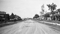
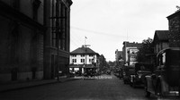
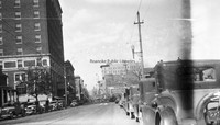
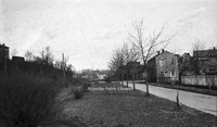
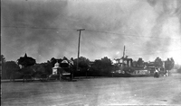
RNRV50 Campbell Avenue

A streetcar travels along Campbell Avenue near the intersection with Jefferson Street. Terry Building visible at right.
RNRV5 Davis Children

Paul, Edith, and Frangie Davis with Frank the horse at Davis home on Salem Avenue.
RNRV49 Burrell Memorial

Ambulance in front of Burrell Memorial Hospital. Roanoke's first African-American hospital, Burrell Memorial, was founded in 1915 in a small cottage on Henry Street. It soon outgrew the Henry Street location and moved into the former Alleghany…
RNRV48 Police Officers

Chief of Police W. J. Rigney (front passenger) with other unidentified police officers.
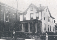
RNRV47 Danmore Family

Mr. and Mrs. Danmore at their home at 413 3rd Street NW.
RNRV46 Blackwell Grocery

J.E. Blackwell Grocery, formerly located at 4 Market Square.
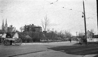
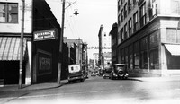
RNRV45 Campbell and Jefferson

A busy day at the intersection of Campbell Avenue and Jefferson Street. The Terry Building is visible in the background.
RNRV44 Streetcar Conductors

Roanoke Railway & Electric streetcar conductors.
RNRV42 N&W Baseball Team

Norfolk & Western baseball team.
RNRV41 N&W Employees

Norfolk & Western employees in front of Norfolk & Western offices.
RNRV40 Eagles Band

Eagles Band.
RNRV4 Paul Davis

Dr. Paul Davis holds his daughter Pauline while on leave during World War I. He was awarded the Croix de Guerre for his service in French hospitals.
RNRV39 Auto Tire Shop

Auto Tire Shop, formerly located at 501 2nd Street SW.
RNRV38 Horse and Buggy

Horse and buggy in Downtown Roanoke.
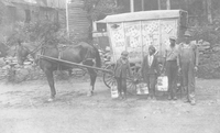
RNRV37 Roanoke Ice

Workers deliver ice for Roanoke Ice Corporation. Roanoke Ice Corportation began operations in 1913 after Consumer Ice Company and Griggs Packing Company.
RNRV36 Enon Baptist

Group photo of members of Enon Baptist Church.
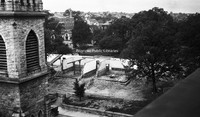
RNRV35 Rockledge Inn

Rockledge Inn on Mill Mountain.
RNRV34 High Street Baptist

Presentation of an auto to Reverend W. E. Lee, of High Street Baptist Church for the church’s 41st anniversary.
RNRV33 Crystal Spring

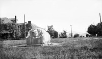
Crystal Spring reservoir and pump house. Crystal Spring was one of the city's earliest landscaped parks. It was designed and managed by Roanoke Gas and Water Works.
RNRV32 Mountain Park

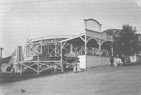
Shooting gallery, The Thriller roller coaster, and bowling alley at Mountain Park.
RNRV31 W.J. Rigney

W.J. Rigney was Chief of Police for the City of Roanoke from 1919 through 1928. Rigney had been appointed Chief to fill the vacancy caused by the death of former Chief A.H. Griffin.
RNRV30 Beckner Family

Family Photo: Front row, 6th from left Isabell Clingenpeel, 7th from left Carl Steele, 8th from left Helen Clingenpeel, 9th from left Lewis Clingenpeel; Back row, 11th from left John Beckner, 12th from left Jackson Beckner, and 13th from left Ann…
RNRV29 Alma Steele

At left is Alma Beckner Steele with two unidentified women.
RNRV28 Steele Family

Photo of members of the Steele Family. Front row, 3rd from left: Carl Steele; Back row, 3rd from left John Steele, 4th from left Alma Steele. All others unidentified.
RNRV27 Men in Park

Two unidentified men in a park.
RNRV26 Peach Orchard

Three unidentified men in a peach orchard,
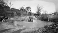
RNRV25 Country Drive

Three unidentified men and a little girl pose with a Mitchell automobile.
RNRV24 Wagon

Wagon pulled by oxen travels through an unidentified residential neighborhood.
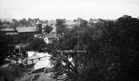
RNRV23 Views

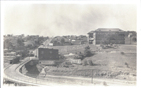
Looking north from South Roanoke toward Downtown. Tinker Mountain is visible in the background.
RNRV22 Mountain Park

Dance Pavilion and The Thriller roller coaster in Mountain Park.
RNRV21 Market Street

Farmer in wagon pulled by oxen on Market Street.
RNRV20 City Market

Customers peruse the City Market.
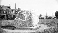
RNRV2 McAfee Knob

An unidentified man stands on the rock formation known as McAfee Knob. McAfee Knob is one of the most photographed places on the Appalachian Trail.
RNRV19 Mountain Park

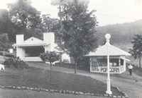
Popcorn stand at Mountain Park. Lillie Solleday on right.
RNRV18 Mountain Park

Check Room and Snack Stand in Mountain Park.
RNRV17 Confederate Veterans

Parade participants for Confederate veterans ride a float through Downtown in conjunction with reunion.
RNRV16 Confederate Veterans

Confederate veterans parade through Downtown in conjunction with reunion.
RNRV15 Confederate Veterans

Confederate veterans parade through Downtown in conjunction with reunion.
RNRV14 Vest Furniture

Vest Furniture Company, formerly located at 109 Campbell Avenue SW. Sid Vest, owner, is pictured in white shirt.
RNRV13 VFW Banquet

Professor Charles Rowe and his Rhythm Boys perform for a Veterans of Foreign Wars banquet at the Hotel Roanoke.
RNRV12 John Gibson Davis

Dr. John Gibson Davis.
RNRV11 Edith Paine

Edith Davis Paine holds an air rifle at the Davis home on Salem Avenue.
RNRV10 Davis Family

Zora and Dr. John G. Davis and children with longtime housekeeper, Vivvie.
RNRV1 Appalachian Power

Group photo of Appalachian Power Company workers in Anawalt, West Virginia to install power lines. Arch Stockton holds rolled blue prints and reins of horse.
RNC 94 Avon Road
Looking north on Avon Road at the intersection with Sherwood Avenue.
RNC 9 St. Andrews
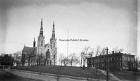
St. Andrews Catholic Church.
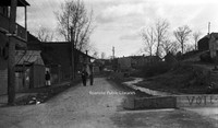
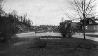
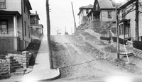
RNC 86 Orange Avenue
Driving could be a challenge on Orange Avenue in its early days. View is looking west near Gainsboro Road.
RNC 85 Tinker Mountain
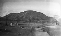
A view of Tinker Mountain.
RNC 84 Gregory Avenue
Gregory Avenue at the intersection with 2nd Street NE.
RNC 81 Church Avenue
Looking east on Church Avenue from the 100 block.
RNC 80 WWI Monument
This monument was erected in 1925 by the Margaret Lynn Lewis Chapter of the DAR to honor Roanoke soldiers who served in World War I. It is located in Argonne Circle on King George Avenue.
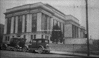
RNC 8 Wilson & Company
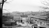
Wilson & Company, seen in the foreground, was a wholesale meat company. It was located at 312 Campebell Avenue SE. Hotel Roanoke and N&W General Offices can be seen in background.
RNC 73 N&W Underpass
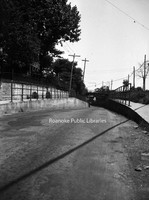
One-lane road under a Norfolk & Western underpass through which traffic accessing 460 East would pass.
RNC 72 2nd Street
Looking north on 2nd Street just beyond Patton Avenue..
RNC 70 Tinker Creek

A view of Tinker Creek.
RNC 66 2nd Street
Looking north on 2nd Street NE at the intersection with Patton Avenue.
RNC 65 2nd Street
Looking north on 2nd Street NE. Lick Run is the stream at right. Extreme right is the location of I581.
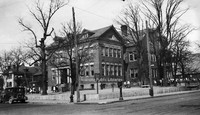
RNC 64 Commerce Street School Site
A nearly gone Commerce Street or First Ward School. The school stood at Church Avenue and 2nd Street and was razed to make way for the post office.
RNC 63 Commerce Street School Site
A nearly gone Commerce Street or First Ward School. The school stood at Church Avenue and 2nd Street and was razed to make way for the post office.
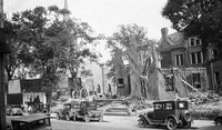
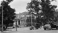
RNC 60 Church Avenue
Demolition of St. John's Episcopal and a house on Church Avenue to make way for the post office.
RNC 56 Jefferson Street
Looking north on Jefferson Street from Campbell Avenue.
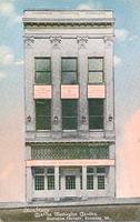
RNC 55 Patrick Henry
The Patrick Henry Hotel.
RNC 54 Jefferson Theatre
Jefferson Theatre, formerly located at 417 S. Jefferson Street.
RNC 52 Church Avenue
Commerce Street School being razed to make room for the post office. Greene Memorial United Methodist Church can be seen in background.
RNC 51 Municipal Building
A view of the municipal building from the YMCA.
RNC 50 Franklin Road
A view of the 200 block of Franklin Road, where the Verizon building sits today. First Baptist Church can be seen over the buildings at left. The building on the right with the round portion was the original First Baptist Church.
RNC 5 Mick or Mack
Mick or Mack, formerly located at 310 2nd Street.
RNC 47 Monticello
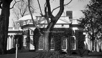
Side view of Monticello.
RNC 42 Jefferson Street
Looking north on Jefferson Street from Elmwood Park.
RNC 41 Big Oak Filling Station
Big Oak Filling Station was located around the 2500 block of Williamson Road.
RNC 40 Commerce Street School
Commerce Street School, also called First Ward School, was located at the corner of Church Avenue and 2nd (Commerce) Street. Built in 1890, it was razed in 1929 to make room for the post office.
RNC 4 Shenandoah
Austin & Martin Auto Repair, formerly located at 223 Shenandoah Avenue NW.
RNC 39 N&W Freight Station
Lots for sale in front of the Norfolk & Western freight station on Norfolk Avenue.
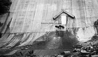
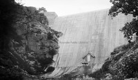
RNC 38 Carvins Cove Dam
Carvins Cove Dam shortly after completion. The reservoir would not be complete until the 1940s.
RNC 37 Carvins Cove Dam
Carvins Cove Dam shortly after completion. The reservoir would not be complete until the 1940s.
RNC 3 N&W Salvage
Norfolk & Western Salvage Warehouse, formerly located at 201 Campbell Avenue SE.
RNC 29 GW Copenhaver
Vacant storefront on Williamson Road between Church Avenue and Kirk Avenue. The building was once occupied by blacksmith G.W. Copenhaver. The site is now a parking lot.
RNC 24 Memorial Avenue
Streetcar tracks on the 700 block of Memorial Avenue.
RNC 2 Highland Park School
Highland Park Elementary School, located at 1212 5th Street.
RNC 18 Quick Way
Quick Way convenience store, located at 2209 Brandon Avenue.
RNC 17 Windsor Apartments
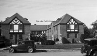
Apartments located at 2049 Windsor Avenue at the corner of Brunswick Street.
RNC 16 Heironimus
John Nolen's plans for the City of Roanoke on display in the windows of Heironimus.
RNC 152 WWI Monument
This monument was erected in 1925 by the Margaret Lynn Lewis Chapter of the DAR to honor Roanoke soldiers who served in World War I. It is located in Argonne Circle on King George Avenue.
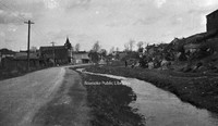
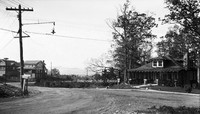
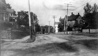
RNC 150 Orange Avenue
Orange Avenue, exact location unknown.
RNC 15 Norfolk Avenue
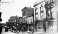
A view of Norfolk Avenue includes Bannister's Place (a boarding house) and HC Barnes Pharmacy. Buildings were located roughly where the Wells-Fargo Tower is today.
RNC 148 Carvins Cove Dam
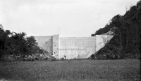
Carvins Cove Dam Shortly after completion. The reservoir would not be complete until the 1940s.
RNC 147 Carvins Cove Dam
Carvins Cove Dam Shortly after completion. The reservoir would not be complete until the 1940s.
RNC 146 Municipal Building
View of the Municipal Building from 2nd Street and Campbell Avenue.
RNC 139 Commerce Street School
Demolition of the Commerce Street School, also known as the First Ward School.
RNC 132 Church and 2nd
Buildings once located at 2nd Street and Church Avenue where the Commonwealth Building stands today.
RNC 130 2nd Street
Looking north on 2nd Street NE.
RNC 120 6th Street SE
Looking north on 6th Street SE from Tazewell Avenue.
RNC 118 Mill Mountain
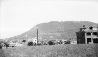
A view of Mill Mountain from Old Southwest.
RNC 117 Woodlawn Avenue
Woodlawn Avenue at the intersection with Montgomery Avenue.
RNC 11 Roanoke High School
Roanoke High School was formerly located on the northeast corner of Church Avenue and 3rd Street where the Noel C. Taylor Municipal building stands today.
RNC 101 Jefferson Street
Home formerly located at 815 S. Jefferson Street.
RNC 10 Fire Station 7
The original Fire Station 7, located at 1742 Memorial Avenue.
Richard T. Edwards

Date of Birth: April 15, 1911
Mayor from September 1, 1946 to August 31, 1948
Date of Death: December 11, 1968
Mayor from September 1, 1946 to August 31, 1948
Date of Death: December 11, 1968
Remodeling Roanoke
Report by Landscape Architect, John Nolen, submitted to the Committee on Civic Improvement, which addresses the following: a plan for the city, provisions for business, streets, parkways and thoroughfares, recreation grounds, and examples and methods…
Reminiscences

This document has focused on the memories of many residents from videotaped interviews (converted to disks) north and south of U.S. Route 460 in eastern Roanoke County and southern Botetourt County to the Bedford County line, and west on Alternate…

Register of Admissions and Discharges: Roanoke City Almshouse

This register documents residents of the Almshouse or "Poor House" of the City of Roanoke.
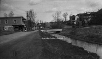
RC9 Russell Avenue

A view of Russell Avenue in Norwich.
RC8 Roanoke Avenue

A view of Roanoke Avenue in Norwich.
RC7 VHBC Parishioners

Parishioners in front of chapel of Virginia Heights Baptist Church.
RC6 VHBC Chapel

Chapel of Virginia Heights Baptist Church.
RC5 VHBC Sunday School

Parishioners in front of chapel of Virginia Heights Baptist Church.
RC48 Transportation Museum
The Transportation Museum in Wasena Park submerged in flood waters from the flood of 1985.
RC47 Transportation Museum
Some of the exhibits at the Roanoke Transportation Museum in Wasena Park.
RC46 Transportation Museum
N&W Class J 611 and N&W #6 on exhibit at the Roanoke Transportation Museum in Wasena Park.
RC45 Transportation Museum
Visitors at the Roanoke Transportation Museum formerly located in Wasena Park. The museum opened in 1963.
RC44 Garlands Drugstore

Garland's Drugstore, formerly located at 1327 Grandin Road.
RC43 Garlands Drugstore

An interior view of Garland's Drugstore at its original Grandin Road location.
RC42 Children on Grandin

Unidentified children stand outside of Brice's Drugstore on Grandin Road.
RC41 Virginia Heights Lutheran

Children in front of Virginia Heights Lutheran Church. The church was the predecessor of Christ Lutheran Church. This chapel was located at what is now 1320 Grandin Road.. Built in 1917, the chapel was in use by the congregation until 1948.
RC40 Lakewood Pond

Pond in Lakewood Park.
RC4 Virginia Heights Elementary

Virginia Heights Elementary School is seen in the background. In the foreground is the foundation being laid for Virginia Heights Baptist Church.
RC39 Lakewood Pond

Pond in Lakewood Park.
RC38 Memorial Bridge

A view of Memorial Bridge
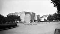
RC37 Raleigh Court Library

Raleigh Court Branch Library, located at 2112 Grandin Road.
RC36 Norwich Bridge

Norwich Bridge
RC35 Harris Hardwood

Harris Hardwood Company office, formerly located just off of Ashlawn Street.
RC34 Patrick Henry High

The old campus-style Patrick Henry High School was dedicated on 17 December 1960. It was replaced with a conventional school building in 2008.
RC33 Wasena Elementary

Wasena Elementary School, located at 1125 Sherwood Avenue.
RC32 Grandin Court Elementary

Grandin Court Elementary School, located at 2815 Spessard Avenue.
RC31 Virginia Heights Elementary

A newly constructed Virginia Heights Elementary School (right) stands next to the old Virginia Heights Elementary.
RC30 Woodrow Wilson Middle

The gymnasium addition at Woodrow Wilson Middle School.
RC3 Virginia Heights Baptist

Sanctuary of Virginia Heights Baptist Church.
RC29 Patrick Henry High

The old campus-style Patrick Henry High School was dedicated on 17 December 1960. It was replaced with a conventional school building in 2008.
RC28 Raleigh Court Elementary

Raleigh Court Elementary School, located at 2202 Grandin Road, opened in 1960 and served students through the end of the 2009 school year.
RC27 Fishburn Park Elementary

Fishburn Park Elementary School, located at 3057 Colonial Avenue.
RC26 Woodrow Wilson Middle

A newly completed Woodrow Wilson Middle School, located at 1813 Carter Road.
RC25 Streetcar 47

Streetcar #47 on Grandin Road. This was the last streetcar to run in Roanoke.
RC24 Memorial Bridge

A crowd gathers for the dedication of Memorial Bridge on 30 August 1926, despite having been open to traffic since 6 May 1926.
RC23 Memorial Bridge

A crowd gathers for the dedication of Memorial Bridge on 30 August 1926, despite having been open to traffic since 6 May 1926.
RC22 Virginia Avenue Bridge

The Virginia Avenue Bridge or Woodrum Bridge was the predecessor to Memorial Bridge.
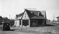
RC21 Grandin Road Pharmacy

Grandin Road Pharmacy. Located at 1314 Grandin Road, the building is now how to Gracie's Place Pizzeria and Local Roots Restaurant.
RC20 Shirley and Greenwood

Looking north on Greenwood Road from the intersection with Shirley Avenue.
RC2 Virginia Heights Baptist

Chapel and first sanctuary of Virginia Heights Baptist Church.
RC19 Grandin and Memorial
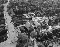
Aerial view of the intersection of Grandin Road and Memorial Avenue.
RC18 Garlands Drugstore

Garland's Drugstore under construction. Garland's opened in 1953.
RC17 Mick-or-Mack

Construction of Mick-or-Mack Grocery, located at 1312 Winborne Avenue.
RC16 Memorial Bridge
Aerial view of Memorial Bridge.
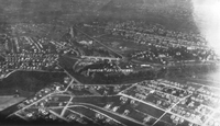
RC15 Virginia Heights
Aerial view of Virginia Heights. Evergreen Cemetery is visible in the foreground; Memorial Bridge is visible in the lower right.
RC14 Norwich

Looking south toward Norwich at Bridge Street.
RC13 Bridge Street

Looking north on Bridge Street at the old truss bridge crossing the Roanoke River.
RC12 Row Houses

Row houses were constructed in Norwich to house the laborers who worked in the various industries in the area.
RC11 Bridge Street

Buildings along Bridge Street in Norwich.
RC10 Bridge Street

A view of Bridge Street in Norwich.
RC1 Memorial Bridge

Memorial Bridge under construction. Virginia Avenue bridge visible on left.
Ralph K. Smith

Date of Birth: July 19, 1942
Mayor from July 1, 2000 to June 30, 2004
Other offices held: Senator, Virginia 22nd District, 2008-2012; Senator, Virginia 19th District, 2012-2016
Mayor from July 1, 2000 to June 30, 2004
Other offices held: Senator, Virginia 22nd District, 2008-2012; Senator, Virginia 19th District, 2012-2016
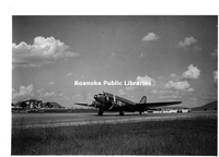
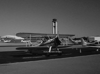
RAC9 Airport Dedication
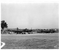
Many types of military aircraft were present in Roanoke at the dedication of the airport. Among them were the Douglas B-23 Dragon (left) and the Douglas B-18 (right).
RAC80 Woodrum & Donahoe

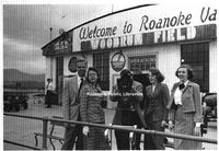
Martha Woodrum and R.J. "Bob" Donahoe at Woodrum Field.
RAC8 First Flight
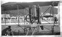
The first flight of an aeroplane in the Roanoke Valley occurred at the Great Roanoke Fair, when aviator Eugene Ely flew his Curtiss Pusher biplane from a hill in South Roanoke. Ely flew across the Roanoke River and circled the fairgrounds, where he…
RAC79 Woodrum Field Dedication

Hostesses gather for a group photograph at the dedication of Woodrum Field. Front row, left to right: Jean Fishburn, Claudine Pendleton, Louise Frantz, Evelyn Correll, Dot Donahoe. Back row, left to right: Mae Williams, Marion Elliott, Jessie Mae…
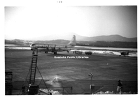
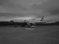
RAC78 Woodrum Field Dedication

A crowd gathers for the dedication of Woodrum Field. The plane in the background is an American Airlines DC-3.
RAC77 VANG Ad
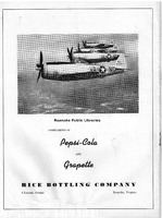
An advertisement for the Rice Bottling Company depicting the Virginia Air National Guard Fighter Squadron.Organized in 1946, the Virginia Air National Guard flew the P-47 Thuderbolt.
RAC76 Woodrum Aerial
A south-facing aerial view of Woodrum Field. In the upper left of this photo, Crossroads Mall can be seen under construction.
RAC75 Woodrum Aerial
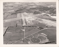
This west-facing photograph shows the configuration of runways. There is construction work at right, indicating the extension of runway 5/23. Still noticeable are the rural surroundings of Woodrum Field. Visible at the bottom is the internal road…
RAC74 Woodrum Aerial
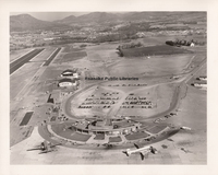
This aerial photograph shows the separation of private aviation (left) and commercial aviation at the front of the terminal. Note the layout of the new parking lot behind the terminal. More passengers began leaving their cars at the airport for…
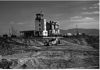
RAC73 Control Tower
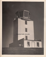
The first freestanding control tower at Woodrum Field, completed in 1943, is seen here. The tower was critical to the airport's operations. In 1943, due to the training of Army and Navy pilots at Woodrum Field, the total number of official…
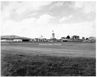
RAC72 Woodrum Field
Roanoke Municipal Airport became Woodrum Field at a dedication ceremony on 13 October 1941. The new airport received a class 3-A rating and American Airlines reestablished passenger service, which had been abandoned in 1937.
RAC71 Marine Corps
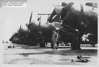
Aircraft from the Marine Corps Air Station at Cherry Point , North Carolina are lined up at Woodrum Field during the hurricane evacuation in September 1945.
RAC70 Piedmont Airlines
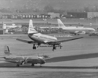
This unusual photograph illustrates the increased traffic of Piedmont Airlines in and out of Roanoke and the transition from propeller aircraft to jets. The prop aircraft landing is a Martin 4-0-4; the aircraft at lower left is a Nihon YS-11; and the…
RAC7 Lemon, Clayton
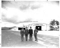
This image shows Clayton Lemon standing in front of the hangar that housed his company, Virginia Airmotive, at the time. Lemon was one of the first pilots in Roanoke to fully understand the "business" of aviation and had a long career at Woodrum…
RAC69 RRA Terminal
Postcard depicting the current terminal at Roanoke-Blackburg Regional Airport. The terminal opened on 13 September 1989.
RAC68 Woodrum Field
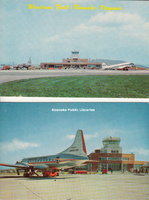
Postcard depicting Woodrum Field.
RAC67 Trussmark Field
The current Trussmark field in Salem. The field is located along the Roanoke River adjacent to an industrial complex. This was the early location for the Salem auxiliary field used by naval aviation cadets enrolled at Roanoke College. The shorter…
RAC66 Trussmark Field
The current Trussmark field in Salem. The field is located along the Roanoke River adjacent to an industrial complex. This was the early location for the Salem auxiliary field used by naval aviation cadets enrolled at Roanoke College. The shorter…
RAC65 RRA Tower
This photograph shows the control tower at Roanoke Regional Airport that wsa commissioned in 2004. The large hangar at left was built bby Piedmont Airlines in the 1960s, and the emergency services facility (foreground) was placed into service in…
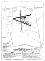
RAC64 1944 Map
This blueprint of the Roanoke Municipal Airport shows its phases of development in 1944.
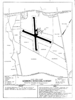
RAC63 1942-43 Map
This blueprint of the Roanoke Municipal Airport shows its phases of development from 1942 through 1943.
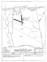
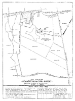
RAC62 1940-41 Map
By 1941, the Roanoke Municipal Airport had seen tremendous development, as evidenced by this 1940-1941 map.
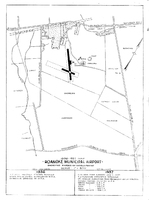
RAC61 1938-39 Map
This blueprint of the Roanoke Municipal Airport shows its phases of development from 1938 through 1939.
RAC60 1936-37 Map
Development of the Roanoke Municipal Airport by 1937 is seen in this blueprint.
RAC59 1934-35 Map
This blueprint of the Roanoke Municipal Airport shows its phases of development from 1934 through 1935.
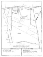
RAC58 1930-33 Map
This blueprint of the Roanoke Municipal Airport illustrates its development between 1930 and 1933. According to data on the blueprint, the Cannaday farm was recommended as the site for a municipal airport by the Department of Commerce in February…
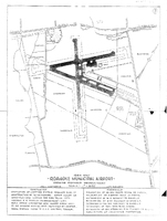
RAC57 1928 Map
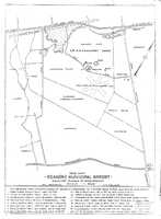
This 1928 city map shows the area where the airport would be located, noting the location of the airfields. With the development of a municipal airport, particularly under the management of Frank Reynolds and Clayton Lemon, interest in aviation…
RAC56 Air Show
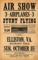
George Mason, like many early aviators, conducted air shows as a means to both entertain and earn income. This undated poster promotes an air show at Moomaw Field in Elliston, Virginia, with Mason billed as the "Nationally Known Flying Salesman and…
RAC55 Plaque
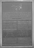
Mounted inside the Roanoke Regional Airport terminal is a plaque placed in the airport as a tribute to those aviation pioneers and advocates who had the vision and fortitude to make air service a reality in the Roanoke area. The names upon the…
RAC54 Landmark Aviation
This building houses the fixed-base operation (FBO) of Landmark Aviation at the Roanoke Regional Airport. FBOs have evolved from very simple operations to full-service onces that provide fuel, maintenance, pilot support services and more. The…
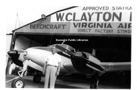
RAC53 Virginia Airmotive
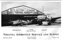
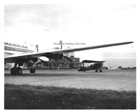
This is an advertisement for Virginia Airmotive Service and Supply, a business owned and operated by W. Clayton Lemon at Woodrum Field. The aircraft are identified as a Beechcraft (left) and a Stinson (right).
RAC52 Terminal Snow
The airport engages in regular winter activity for Southwestern Virginia, snow removal. In the early days of the airport, snow would cause major delays in operations, measured in days, not hours. In later years, airports, including Woodrum Field,…
RAC50 Woodrum Flying Service
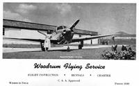
An advertisement for Woodrum Flying Service, which offered flying lessons, charters, and rentals.
RAC49 USAF C97
This photograph shows a US Air Force Boeing C-97 Stratofreighter parked on the ramp at Woodrum Field. Only sixty of these planes were built. The Roanoke airport has been and remains important to the military subce World War II, either for training,…
RAC48 American Airlines
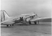
American Airlines restored air service, notably passenger and airmail, to Woodrum Field in the 1940s. This photograph appears to have been taken at Woodrum during World War II. The statement painted on the rudder of this DC-3 reads, "Buy War…
RAC47 Wind Indicator
This is a close-up view of the tetrahedron wind-direction indicator installed at Woodrum Field. The device allowed pilots to visually determine the wind direction prior to landing in order to choose the best runway. The device became obsolete as…
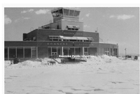
RAC46 Woodrum Field
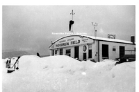
Woodrum Field buried under snow.
RAC45 Jeep Crash Truck
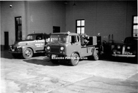
Seen here is a Jeep Forward Control crash truck that was added to the emergency fleet at Woodrum Field.
RAC44 Landmark Aviation
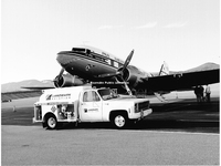
This photograph shows a privately owned, fully restored DC-3 being refueled by Landmark Aviation at Roanoke Regional Airport. The appearance of such a vintage aircraft in restored, flying condition has become increasingly rare with limited air shows…
RAC43 Playboy
This DC-9 was purchased by Hugh Heffner in 1970 as the Playboy airplane, known as Hare Force One.
RAC42 Eastern DC3
An Eastern Airlines DC-3, part of the "Great Silver Fleet" takes off from Woodrum Field.
RAC41 Fire Trucks
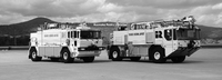
These huge vehicles represent the evolution of fire-fighting and emergency service equipment needed by airports as the number of flights increased and the size of the aircraft became larger. Both trucks are shown at Roanoke Regional Airport. They…
RAC40 Entrance Sign
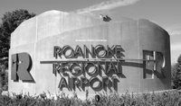
The main entrance sign for the Roanoke Regional Airport off of Aviation Drive. The innovative sign, designed by URS of Baltimore, Maryland, incorporates the mountains, the Mill Mountain Star and a very unique 'R' to the left, the center of which is…
RAC4 Woodrum, Martha
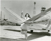
Martha Anne Woodrum displays her trophy for winning a trancontinental air race in 1950. She and her Beechcraft Bonanza were sponsered by Johnson-Carper Furniture of Roanoke.
RAC39 Lifeguard
A recent promotional photograph depicting Carillion Roanoke Memorial Lifeguard 10, 11 and 12 in front of Carillion Roanoke Memorial Hospital.
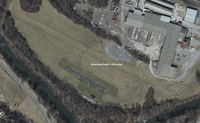
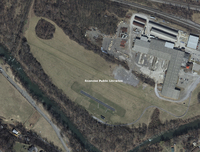
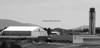
RAC38 Cook Field
This photograph shows the location of the Appalachian Power substation adjacent to the rail line where Cook Field was formerly located. Cook Field was leased by Frank Reynolds and Clayton Lemon to provide an airstrip for local fliers in the late…
RAC37 Civil Air Patrol
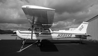
A Cessna 172, one of 500 Cessna aircraft owned by the Civil Air Patrol (CAP) is seen here. These aircraft are rotated periodically among active stations, including Roanoke Regional Airport. The CAP was established in 1941 to serve as a civilian…
RAC36 2013 Aerial
An aerial view of Roanoke Regional Airport.
RAC35 1967 Aerial
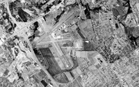
An aerial view of Woodrum Field. I-581 opened in 1965 and can been seen at left of the airport.
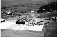
RAC34 1953 Aerial
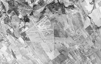
An aerial view of Woodrum Field.
RAC33 1947 Aerial
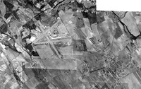
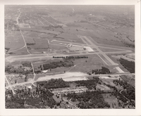
An aerial view of Woodrum Field.
RAC32 Williamson Road
In this aerial photograph, Williamson Road runs along the left side. The small structure in the open space at center is the present-day location of Breckenridge Middle School, formerly William Fleming High School. In 1921, the federal government…
RAC31 Trout Field
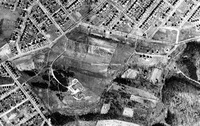
Trout Field is directly in the center of this aerial photograph. Fairview Cemetery is the rectangular area at top with the teardrop-shaped driveway in its center. This view illustrates why a cemetery served as a good navigational point for early…
RAC30 Shrine Hill
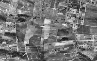
This aerial photograph shows the area where Patrick Henry High School is located today. During the 1920s, the pasturelands served as an early airfield known as Shrine Field. The land was owned by the Shriners in hopes of erecting a large Masonic…
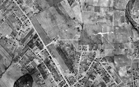
RAC29 Horton Field
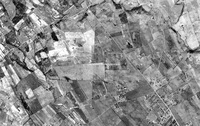
This 1937 aerial photograph shows the location of Horton Field, which was on the Horton Farm near the present-day intersection of 24th Street and Melrose Avenue. It is believed that the first plane to land at Horton Field in 1919 was a barnstormer…
RAC28 1937 Aerial
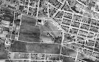
Aerial view of Roanoke Municipal Airfield.
RAC26 Cannaday, Charles
This photo is of Charles "Chuck" Cannaday, grandson of Dr. A.A. Cannaday who once owned the land where the Roanoke Regional Airport is located today. He is pictured in his Pitts special "Cloud Dancer". This airplane was the star of the movie by the…
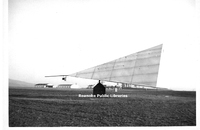
RAC25 Rotorway Executive
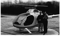
Warren and Hassie Gilbert are pictured beside their Rotorway Executive helicopter that was assembled by Warren Gilbert at their home. The aircraft was registered with the Federal Aviation Administration around the time this photo was taken.
RAC24 Airport Managers
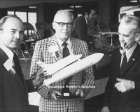
The first three managers of the airport are shown in this image from the 1970s. From right to left is Bob Dunahoe, manager from 1937-1945; Marshall L. Harris, manager from 1945-1974; and Bob Poole, manager from 1974-1991. In 1991, Jacqueline L.…
RAC23 Military Aircraft
Unknown military aircraft.
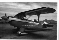
RAC22 Stearman
A 1942 Stearman bi-plane is parked on the south ramp at Roanoke Regional Airport. The tower stands in the background. Restoration of these vintage planes has allowed new generations to relive aviation history. Such planes used to be seen regularly…
RAC21 Air Force One
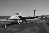
Roanoke Regional Airport was host to this Boeing 757, and on that date the aircraft was designated as "Air Force One" because President Barack Obama was on board. Air Force One pilots have often used Roanoke Regional Airport as a site for "touch and…
RAC20 C-17 Globemaster
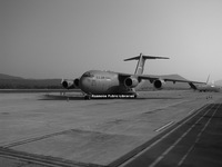
With Tinker Mountain as a backdrop, a C-17 Globemaster sits on the north ramp at Roanoke Regional Airport. This aircraft, one of the US Air Force's largest transport planes, has significant operational flexibility.
RAC19 Private Aircraft
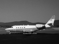
Unknown private aircraft
RAC18 Woodrum Field
The main facilities at Woodrum Field are seen here as they existed during much of the 1940s. From left to right are Clayton Lemon's hangar, the hangar leased to Martin O'Brien Flying Service (which trained naval cadets until 1944), the terminal…
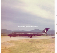
RAC17 Piedmont Airlines
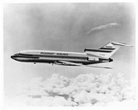
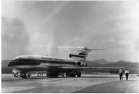
This promotional photograph shows a Piedmont Airlines Boeing 727. Piedmont began using the 727 in January of 1967 in Roanoke. The following year, Piedmont placed the Boeing 737 into service in Roanoke.
RAC16 Terminal Construction
Starting in the fall of 1950, construction began on the first modern terminal facility at Woodrum Field. It was designed to house commercial air service, administrative functions and government services such as weather and air-traffic control. …
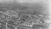
RAC15 Roanoke Municipal Airport
An aerial view of Roanoke Municipal Airport.
RAC14 Woodrum Field
This photograph was taken three days before the dedication and renaming of Roanoke Municipal Airport to Woodrum Field. The airport is receiving a final inspection, having just undergone a $400,000 multifaceted construction project as a WPA Certified…
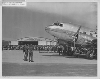
RAC13 Hillman, Wes
Wes Hillman sits in his Waco "F" in front of the terminal at Woodrum Field. At left is a Pan American DC-4 (most likely a charter, as Pan Am did not serve Roanoke). A Piedmont Airlines DC-3 can be seen in the distance at right.
RAC12 Piedmont Airlines
January 1967 saw the introduction of the Boeing 727 by Piedmont Airlines to its routes. The first 727 to visit Woodrum Field is seen here. Just a few months earlier, in November 1966, Piedmont Airlines had opened routes through Roanoke to New York.…
RAC11 Woodrum Field
The progress made at Woodrum Field is seen here in 1971. Among the facilities shown are the terminal dedicated in 1953, the nose-in hangar (left of center, top), general aviation hangars and the service hangar for Piedmont Airlines (upper right).…
RAC10 Airport Terminal
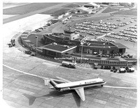
Customers at Woodrum Field pose in front of the soon-to-be-demolished terminal building. Shown here, from left are Mike Davis, June Carr, Parker Smith (behind the scope), Lou Urquhart, and Jo Hambrick. Note the American Airlines and Piedmont logos…
RAC1 Mason, George H.
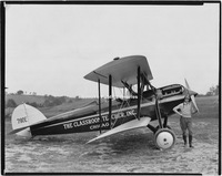
An early Roanoke aviator who used flight for commercial success was George H. Mason, shown here in 1929 with his Waco. Mason sold textbooks throughout Virginia, the Carolinas, George and Florida. He would circle a town, drawing attention, and then…
PS 90.0 Hitching Post Motel

The Hitching Post Motel, formerly located at 7656 Williamson Road.
PS 9.0 Mick or Mack

Mick or Mack, formerly located in the 5300 block of Williamson Road in what is now Williamson Road Plaza.
PS 81.0 Oak Hill Academy Board

Group photograph of the Oak Hill Academy Board of Trustees.
PS 76.0 WP Swartz

W.P. Swartz & Company, formerly located at 421 Luck Avenue, SW.
PS 74.0 Whitehead Plumbing

Employees of Whitehead Plumbing next to trucks at 1114 Moorman Avenue, NW.
PS 71.0 Propst-Childress

Propst-Childress Shoe Company window display. Store was located at 306 S. Jefferston Street.
PS 66.0 Carlton Terrace

Carlton Terrace Apartments, formerly located at 924 S. Jefferson Street.
PS 64.0 Gulf Station

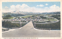
Gulf Service Station, formerly located at the corner of Plantation Road and Williamson Road. . Tinker Mountain is seen in the background.
PS 63.2 Cheds

Ched's Department Store, possible located on Route 460 in Blacksburg.
PS 63.1 Cheds

Ched's Department Store, possibly located on Route 460 in Blacksburg.
PS 6.1 Municipal Building

Noel C. Taylor Municipal Building, located at 215 Church Avenue.
PS 59.2 Universal Ball

Universal Ball Company, formerly located in the 1900 block of Progress Drive, SE.
PS 59.1 Universal Ball

Universal Ball Company, formerly located in the 1900 block of Progress Drive, SE.
PS 53.0 VEC

Virginia Employment Commission, formerly located at 1204 Franklin Road, SW.
PS 49.0 Colonial Tourist Home

Colonial Tourist Home, formerly located at 3824 Williamson Road.
PS 37.0 Ferrum Graduates

Class graduates of Ferrum College in front of Vaughn Chapel.
PS 33.2 Second Presbyterian Choir

Second Presbyterian Church junior choir.
PS 33.0 Second Presbyterian Choir

Second Presbyterian Church junior choir.
PS 283 Capitol Saloon

Unidentified men stand outside the Capitol Saloon once located at 23 Salem Avenue, SW.
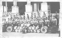
PS 281 WFHS Band

Group photograph of the William Fleming High School band.
PS 280 Roanoke Police Department

Composite photograph of Roanoke Police Department. Pictured are: F.A. Gates, F.H. Webb, D.H. Jamison, L.C. Bailey, J.J. Field, A. Anderson, W.F. Tickle, R.S. Cassell, A.M. Butler, O.H. Mason, C.M. Porter, W.D. Adams, R.M. Harris, J.E. Lemon, E.R.…
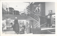
PS 28.7 Leggetts

Interior view of salon in Leggett's Department Store, formerly located at 112 Campbell Avenue, SW.
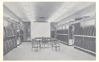
PS 28.5 Leggetts

Interior view of fabric department in Leggett's Department Store, formerly located at 112 Campbell Avenue, SW.
PS 28.4 Leggetts

Interior view of fabric department in Leggett's Department Store, formerly located at 112 Campbell Avenue, SW.
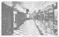
PS 28.3 Leggetts

Interior view of Leggett's Department Store, formerly located at 112 Campbell Avenue, SW.
PS 28.2 Leggetts

Interior view of men's department in Leggett's Department Store, formerly located at 112 Campbell Avenue, SW.
PS 279 Woolworth Employees

Composite photograph of F.W. Woolworth Roanoke employees. Pictured are: Mable Plunkett, Pearl Johnson, Evelyn Atkins, Rethia McKinney, Nadine James, Zola Plunkett, Erma Hollins, Josephine Jordan, Edna Dearing, Lucille Wright, Thelma Price, Elizabeth…
PS 278 McLellan Employees

Composite photograph of McLellan employees. Pictured are: Lois Carter, Thelma Stewart, Dorothy Dillon, Blanche Webb, Hazel Trew, Helen Whitesell, Hazel Bryant, Gladys Pollard, Sallie Hunt, Elsie Higgins, Helen Harris, Vera Hamilton, W.J. Edwards,…
PS 277 Rotary Members

Composite photograph of Christiansburg-Blacksburg Rotary Club members. Pictured are: Bob Begg, D. DeHart, Russ Jones, Burky Grimes, Dick Bolton, John Whittemore, Arch Cromer, Billy Byrne, Gratton Jones, Ben Warriner, Lee Cole, Doc Marshall, Mike…
PS 276 Schulte-United Employees

Composite photograph of Schulte-United personnel. Pictured are: Sibil White, Evelyn Reynolds, Elizabeth Drumheller, Fern Blanton, Mary Baker, Gaphred Jones, Mable Burke, Sylvia Dent, Pauline Giesen, Naomi Wyne, Polly Martin, Virginia Dickerson, Dovie…
PS 275 USPS Employees

Composite photograph of personnel of the Roanoke United States Post Office. Pictured are: E.M. Wright, B.S. Sisson, C.D. Spangler, I.C. Barnhart, J.P. Broughman, O.E. Hammer, C.H. Owen, John Robertson, R.W. Adams, R.P. Grogan, D.T. Alley, W.A. Clark,…
PS 274 MWC Employees

Composite photograph of Roanoke store employees of Martha Washington Candies, Inc. Pictured are: Christine Bailey, Minnie Markham, Ethel Cecil, Evelyn Harris, Edith Bennett, Alberta Anderson, Patsy Bishop, Ruby Parsons, Frances Pace, Juanita Fisher,…
PS 273 Junior Women's Club

Composite photograph of Roanoke Junior Woman's Club members. Pictured are: Florence Chick, Naomi Wade, Louise Simmerman, Frances Parrish, Catherine Phipps, Terecia Wingate, Mildred Stickley, Helen Lorenzen, Dorothy Snedegar, Betty Norris, Vivian…
PS 272 RRE Employees

Composite photograph of Roanoke Railway & Electric Company/Safety Motor Transit Corporation employees. Pictured are: R.M. Pendleton, L.O. Kesler, R.C. Richards, R.B. Crider, B.F. Spencer, E.R. Mitchell, J.W. Hale, E.H. Hammersley, R.C. Nimmo, T.H.…
PS 271 JNF Employees

Composite photograph of Jefferson National Forest Supervisor's Headquarters Staff. Pictured are: Mildred M. Hann, Gertrude W. Carter, Betty A. Nelms, Marian V. Hall, Grace M. Shelton, Grace G. Easter, Lessie Moore, Mamie E. Nichols, Helen E.…
PS 263.1 WT Grant

Interior view of W.T. Grant department store, formerly located at 27 Campbell Avenue, SW.
PS 263 WT Grant

Interior view of W.T. Grant department store, formerly located at 27 Campbell Avenue, SW.
PS 261.2 Davidsons

Window displays at Davidson's Menswear.
PS 261.1 Davidsons

Window displays at Davidson's Menswear.
PS 260.1 Noland Company

Noland Company's former location at 1226 Centre Avenue, NW.
PS 260 Noland Company

Noland Company's former location at 1226 Centre Avenue, NW.
PS 22 J.W. Burress

J.W. Burress Construction and Industrial Equipment, formerly located at 1701 Shenandoah Avenue, NW.
PS 209 Liberty Limestone

Liberty Limestone Corporation office building, formerly located at 19857 Main Street in Buchanan.
PS 176.2 Roanoke Youth Symphony

Group photograph of Roanoke Youth Symphony.
PS 176.1 Roanoke Youth Symphony

Group photograph of Roanoke Youth Symphony.
PS 176 Roanoke Youth Symphony

Group photograph of Roanoke Youth Symphony.
PS 142 Greene Memorial

Group photograph of Greene Memorial United Methodist Chuch choir.
PS 13.8 Poff Building

Construction of Poff Federal Building, located at 210 Franklin Road, SW.
PS 13.6 Poff Building

Construction of Poff Federal Building, located at 210 Franklin Road, SW.
PS 13.59 Poff Building

A newly completed Poff Federal Building, located at 210 Franklin Road, SW.
PS 13.58 Poff Building

A newly completed Poff Federal Building, located at 210 Franklin Road, SW.
PS 13.57 Poff Building

The entrance of a newly completed Poff Federal Building, located at 210 Franklin Road, SW.
PS 13.510 Poff Building

A newly completed Poff Federal Building, located at 210 Franklin Road, SW.
PS 13.31 Poff Building

Construction of Poff Federal Building, located at 210 Franklin Road, SW.
PS 13.24 Poff Building

Construction of Poff Federal Building, located at 210 Franklin Road, SW.
PS 13.21 Poff Building

Construction of Poff Federal Building, located at 210 Franklin Road, SW.
PS 13.2 Poff Building

Construction of Poff Federal Building, located at 210 Franklin Road, SW.
PS 13.12 Poff Building

Construction of Poff Federal Building, located at 210 Franklin Road, SW.
PS 13.10 Poff Building

Construction of Poff Federal Building, located at 210 Franklin Road, SW.
PS 110.6 HSMM

Employees working in drafting room at Hayes, Seay, Mattern, and Mattern.
PS 110.10 HSMM

Hayes, Seay, Mattern, and Mattern architecural firm, formerly located at 1615 Franklin Road, SW.
PS 109.7 RSO

Group photograph of Roanoke Symphony Orchestra and Chorus.
PS 109 RSO and Chorus

Group photograph of Roanoke Symphony Orchestra and Chorus.
PS 108 Last Supper

Reenactment of the Last Supper at Greene Memorial United Methodist Church.
PS 106 Rutherfoord Family

Julian H. Rutherfoord Family portrait in front of home located at 412 King George Avenue, SW.
PS 104 BSA Troop 21

Boy Scouts of America, Troop 21 in the old Boy Scout room at Greene Memorial United Methodist Church. Pictured are Henry Deaton, Jr., Jimmy King, Alton B. Parker, and Joe Wright.
PS 102 Greene Memorial Choir

Greene Memorial United Methodist Church junior choir.
PS 101 Oral Roberts Campaign

View of Oral Roberts revival campaign taken from the top of Victory Stadium.
PS 10.1 MiniBank

MiniBank in Mick or Mack, formerly located in what is now Williamson Road Plaza.
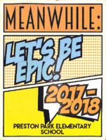
Preston Park Elementary School 2018
Yearbook for Preston Park Elementary School.
Presidents 1986
The Presidents is the annual for Woodrow Wilson Junior High School.
Presidents 1985
The Presidents is the annual for Woodrow Wilson Junior High School.
Presidents 1984
The Presidents is the annual for Woodrow Wilson Junior High School.
Presidents 1982-1983
The Presidents is the annual for Woodrow Wilson Junior High School.
Presidents 1981-1982
The Presidents is the annual for Woodrow Wilson Junior High School
Presidents 1980-1981
The Presidents is the annual for Woodrow Wilson Junior High School.
Presidents 1979-1980
The Presidents is the annual for Woodrow Wilson Junior High School.
Presidents 1978-1979
The Presidents is the annual for Woodrow Wilson Junior High School.
Presidents 1977-1978
The Presidents is the annual for Woodrow Wilson Junior High School.
Presidents 1976-1977
The Presidents is the annual for Woodrow Wilson Junior High School.
Presidents 1975-1976
The Presidents is the annual for Woodrow Wilson Junior High School.
Presidents 1974-1975
The Presidents is the annual for Woodrow Wilson Junior High School.
Presidents 1973-1974
The Presidents is the annual for Woodrow Wilson Junior High School.
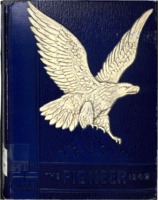
Pioneer 2005

The Pioneer is the annual for Andrew Lewis Middle School.
Pioneer 1998

The Pioneer is the annual for Andrew Lewis Middle School.
Pioneer 1997

The Pioneer is the annual for Andrew Lewis Middle School.
Pioneer 1996

The Pioneer is the annual for Andrew Lewis Middle School.
Pioneer 1994

The Pioneer is the annual for Andrew Lewis Middle School.
Pioneer 1993

The Pioneer is the annual for Andrew Lewis Middle School.
Pioneer 1987

The Pioneer is the annual for Andrew Lewis Middle School.
Pioneer 1986

The Pioneer is the annual for Andrew Lewis Middle School.
Pioneer 1985

The Pioneer is the annual for Andrew Lewis Middle School.
Pioneer 1984

The Pioneer is the annual for Andrew Lewis Middle School.
Pioneer 1983

The Pioneer is the annual for Andrew Lewis Middle School.
Pioneer 1982

The Pioneer is the annual for Andrew Lewis Middle School.
Pioneer 1981

The Pioneer is the annual for Andrew Lewis Middle School
Pioneer 1975
The Pioneer was the annual for Andrew Lewis High School.
Pioneer 1974
The Pioneer was the annual for Andrew Lewis High School.
Pioneer 1971
The Pioneer was the annual for Andrew Lewis High School.
Pioneer 1965
The Pioneer was the annual for Andrew Lewis High School.
Pioneer 1964
The Pioneer was the annual for Andrew Lewis High School.
Pioneer 1960
The Pioneer was the annual for Andrew Lewis High School.
Pioneer 1959
The Pioneer was the annual for Andrew Lewis High School.
Pioneer 1958
The Pioneer was the annual for Andrew Lewis High School.
Pioneer 1957
The Pioneer was the annual for Andrew Lewis High School.
Pioneer 1950

The Pioneer was the annual for Andrew Lewis High School.
Pioneer 1949
The Pioneer was the annual for Andrew Lewis High School.
Pioneer 1948
The Pioneer was the annual for Andrew Lewis High School.
Pioneer 1947

The Pioneer was the annual for Andrew Lewis High School.
Pioneer 1942
The Pioneer was the annual for Andrew Lewis High School.
Pioneer 1941
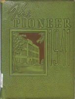
The Pioneer was the annual for Andrew Lewis High School.
Pioneer 1939
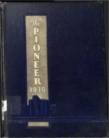
The Pioneer was the annual for Andrew Lewis High School.
Pioneer 1936

The Pioneer was the annual for Andrew Lewis High School.
Pioneer 1934

The Pioneer was the annual for Andrew Lewis High School.
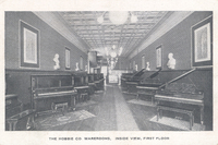
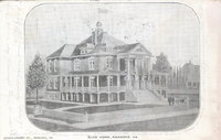
Picturesque Roanoke
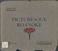
Picturesque Roanoke is "a series of reproductions from photographic views , taken in the City of Roanoke, and the vicinity thereof, especially for this work".
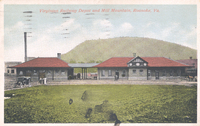
PGCC01 Piney Grove Christian Church

Piney Grove Christian Church.The church was located in Roanoke County and was razed in the early 1970s due to the creation/expansion of Route 419. The church was located where the on-ramp is located from 419 to 220 South, near Tanglewood Mall. The…
PCS11.0
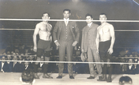
"The largest crowd ever to witness a wrestling bout in Roanoke gave what many regard as the greatest boxing champion that ever lived, Jack Dempsey, a tremendous ovation as he crawled through the ropes to referee the Dan O'Connor-'Father' Lumpkin bout…
PCS10.0
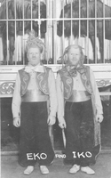
George and Willie Muse were born with albanism resulting in the exploitation in circuses and sideshows with the stage names Eiko and Iko. George and Willie's story is detailed in 'Truevine: Two Brothers, a Kidnapping, and a Mother's Quest' by Beth…
PCS 90.0
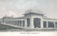
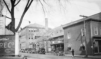
The Randolph Street Market was located at the corner of Williamson Road (Randolph Street) and Campbell Avenue.
PCS 9.0
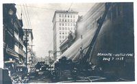
The Schulte-United department store afire as firemen try to contain the blaze.
PCS 89.2
Birds-eye view looking northeast toward the Norfolk & Western General Offices and Hotel Roanoke.
PCS 89.1
Located at Jefferson Street and Williamson Road, the Virginian Railway Station served passengers from 1910 to 1956. It was the only station constructed of brick along the entire length of the Virginian's 608 miles network.
PCS 89.0
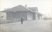
Located at Jefferson Street and Williamson Road, the Virginian Railway Station served passengers from 1910 to 1956. It was the only station constructed of brick along the entire length of the Virginian's 608 miles network.
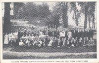
PCS 88.3
Group photo of National Business College students.
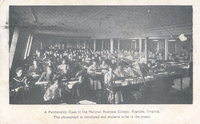
PCS 88.2
A penmanship class in National Business College.
PCS 88.1
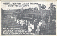
"The student body assembled at the college building on Church Avenue and with well-filled baskets marched to the Norfolk & Western where they boarded a special train chartered for the occasion by Professor Coulter. The management of the Norfolk &…
PCS 88.0
Group photo of National Business College students.
PCS 87.0

The President's house at Virginia Tech.
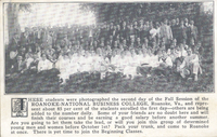
PCS 86.2
Mountain Lake in Giles County.
PCS 86.1
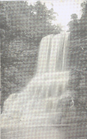
Cascade Falls located in Giles County.
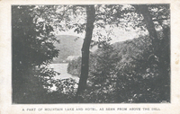
PCS 86.0
Mountain Lake in Giles County.
PCS 85.0
For many years, Salem had also benefited from passenger service provided by the Virginian Railroad. Virginian passenger service in Salem ended in 1954, five years prior to its merger with the N&W.
PCS 84.0
Prominent on the left is a sign for W.B. Dillard Drug Co., Prescription Druggists, Soda and Mineral Waters. Watts Dillard was a prominent Salem business man involved in numerous civic projects. His drugstore, at the corner of Main and College, got a…
PCS 83.0
Roanoke Post Office was located on the northeast corner of Church Avenue and 1st Street.
PCS 82.1
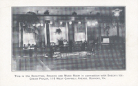
An interior view of the reception, reading, and music room in connection with Sheen's Ice Cream Parlor. Sheen's was located at 119 Campbell Avenue SW.
PCS 82.0
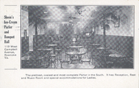
An interior view of Sheen's Ice Cream Parlor, formerly located at 119 Campbell Avenue SW.
PCS 81.0
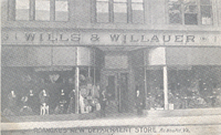
Wills & Willauer was located at 111-113 Campbell Avenue SW.
PCS 80.9
Various buildings on the grounds of Mountain Park. In addition to The Thriller, Mountain Park had a casino, shooting gallery, dance pavilion, and bowling alley.
PCS 80.7
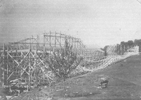
Construction of The Thriller roller coaster in Mountain Park.
PCS 80.6
The Thriller roller coast under construction at Mountain Park.
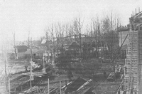
PCS 80.5
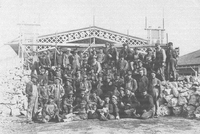
Group photograph of the construction crew at Mountain Park.
PCS 80.4
Men work on building structures in Mountain Park.
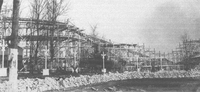
PCS 80.3
Workers raise the infrastructure for The Thriller roller coaster in Mountain Park.
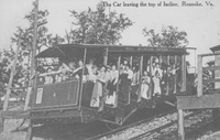
PCS 80.21
Crowds watch as the Mill Mountain Incline makes its journey.
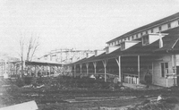
PCS 80.20
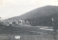
A view of Mountain Park.
PCS 80.2
Construction of The Thriller roller coaster in Mountain Park.
PCS 80.19
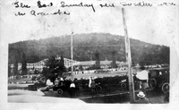
Mountain Park. Caption reads, 'The last Sunday here soldiers were in Roanoke.'
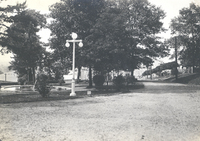
PCS 80.18
Footpaths in Mountain Park.
PCS 80.17
Some concession stands at Mountain Park.
PCS 80.16
A view of Mountain Park.
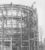
PCS 80.15
Construction of The Thriller roller coaster in Mountain Park.
PCS 80.14
Entrance of The Thriller roller coaster in Mountain Park.
PCS 80.13
Construction of The Thriller roller coaster in Mountain Park.
PCS 80.12
Construction of The Thriller roller coaster in Mountain Park.
PCS 80.11
Men stand on the tracks of The Thriller roller coaster during construction.
PCS 80.10

Various buildings on the grounds of Mountain Park. In addition to The Thriller, Mountain park had a casino, dance pavilion, shooting gallery, and bowling alley.
PCS 80.1

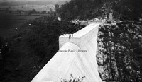
A view of Roanoke from the Mill Mountain Incline.
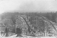
PCS 80.0
Passengers ride the Mill Mountain Incline down Mill Mountain.
PCS 8.1
S.H. Kress Five & Dime was located at 302 S. Jefferson Street.
PCS 8.0
"Commencing yesterday the delivery of ice to consumers by Roanoke Ice Corp. Recently organized to take over the plants of the Consumers Ice Company and the Griggs Packing Company."
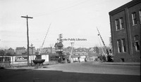
PCS 79.0
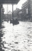
Looking west on a flooded Campbell Avenue near the Jefferson Street intersection.
PCS 78.0
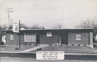
State Farm Insurance Company once had an office at 5005 Williamson Road.
PCS 77.0

The Mexican Craft Shop was located across from the entrance to Hollins University on Route 11.
PCS 76.0
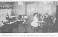
Dr. J. Harry Martin performs an eye exam in his office located at 134 Campbell Avenue SW.
PCS 75.0
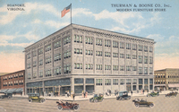
Thurman & Boone was located at 401 S. Jefferson Street.
PCS 74.0
Interior view of The Hobbie Company, formerly located at 14 Campbell Avenue SW.
PCS 73.0

The Elks National Home in Bedford.
PCS 72.0
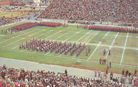
The Corps of Cadets of VMI parades on the football field in a colorful pregame appearance at the Thanksgiving Day classic between VMI and VT at Victory Stadium.
PCS 71.0
A view of Wasena from the north entrance of Wasena Bridge.
PCS 70.0
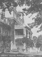
The Virginia College for Young Women was located in the South Roanoke neighborhood at the end of Rosalind Avenue. The college closed in 1933.
PCS 7.0
Home located on Campbell Avenue. Address unknown.
PCS 69.4
Walter S. Slicer's Hospital was located at 601 S. Jefferson Street. The building was later occupied by National Business College.
PCS 69.3
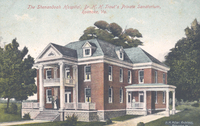
Jefferson Hospital, which was founded in 1907 by Dr. Hugh Trout, was a predecessor to Carilion Roanoke Community Hospital. Formerly located at 1313 Franklin Road SW, the hospital closed in 1967 and was later razed.
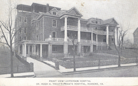
PCS 69.2
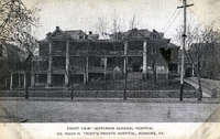
Jefferson Hospital, which was founded in 1907 by Dr. Hugh Trout, was a predecessor to Carilion Roanoke Community Hospital. Formerly located at 1313 Franklin Road SW, the hospital closed in 1967 and was later razed.
PCS 69.1
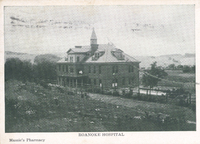
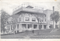
Roanoke Hospital was built in 1893 with the aid of Norfolk & Western and the Roanoke Gas and Water Company. Carilion Roanoke Memorial now occupies the site of the old hospital.
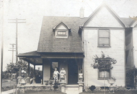
PCS 69.0
The Shenandoah Hospital was located at 712 Campbell Avenue SW.
PCS 68.4
A view of the dining room inside Roanoke Sanitarium. Roanoke Sanitarium was located at 1906 Salem Avenue SW. It was opened by Dr. Walter Slicer in 1911 to treat "nervous and mild mental cases" as well as alcohol and drug addiction. The sanitarium…
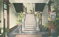
PCS 68.3
A view of the reception hall inside Roanoke Sanitarium. Roanoke Sanitarium was located at 1906 Salem Avenue SW. It was opened by Dr. Walter Slicer in 1911 to treat "nervous and mild mental cases" as well as alcohol and drug addiction. The sanitarium…
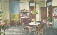
PCS 68.2
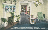
A view of the parlor inside Roanoke Sanitarium. Roanoke Sanitarium was located at 1906 Salem Avenue SW. It was opened by Dr. Walter Slicer in 1911 to treat "nervous and mild mental cases" as well as alcohol and drug addiction. The sanitarium closed…
PCS 68.1
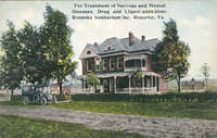
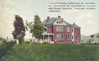
Roanoke Sanitarium was located at 1906 Salem Avenue SW. It was opened by Dr. Walter Slicer in 1911 to treat "nervous and mild mental cases" as well as alcohol and drug addiction. The sanitarium closed in 1913.
PCS 68.0
Roanoke Sanitarium was located at 1906 Salem Avenue SW. It was opened by Dr. Walter Slicer in 1911 to treat "nervous and mild mental cases" as well as alcohol and drug addiction. The sanitarium closed in 1913.
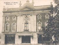
PCS 67.2
The Academy of Music was located in the 400 block of West Salem Avenue. The Academy opened 7 October 1892. After World War II, it fell into disuse and was razed in 1953.
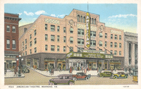
PCS 67.1
The American Theatre once stood on the corner of Jefferson Street and Kirk Avenue. Built in 1928, the theatre remained in operation until 1971; it was razed in 1973.
PCS 67.0
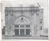
The Jefferson Theatre was located at 417 S. Jefferson Street.
PCS 66.0
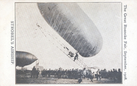
Strobel's Airship at the Roanoke Fair. The airship was designed by Charles J. Strobel, after the general idea of the Zeppelin, and took a championship at the 1904 St. Louis World's Fair. The airship was filled with hydrogen and had a gas engine that…
PCS 65.0
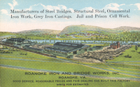
Roanoke Iron & Bridge Works
PCS 64.0
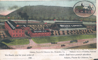
Adams, Payne, and Gleaves was located along the south end of Jefferson Street.
PCS 63.0
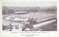
Encampment of the 2nd Virginia Regiment of the National Guard at Maher Field.
PCS 62.0
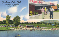
Fairland Lake Club was located at 2611 Ordway Drive NW.
PCS 61.0
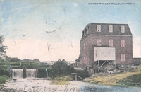
Vinton Roller Mills, along Glade Creek, grew out of mills originally built by David Gish that pre-dated the Civil War. By the Twentieth Century, the remaining mill was owned and operated by James Bowie and produced three kinds of flour. By 1924, the…
PCS 60.0

A view of First Street in Vinton.
PCS 6.4
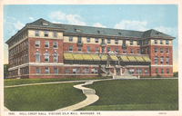
Hill Crest Hall was the female dormitory for employees of American Viscose.
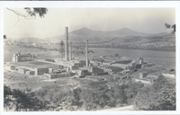
PCS 6.3
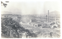
Birds-eye view of American Viscose. American Viscose, once the world's largest producer of artificial silk, opened in 1917. By the 1920s, the plant employed more than 5,000 people. American Viscose remained in business until 1948. Hill Crest Hall, a…
PCS 6.2
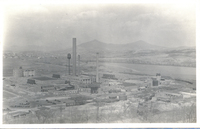
Birds-eye view of American Viscose. American Viscose, once the world's largest producer of artificial silk, opened in 1917. By the 1920s, the plant employed more than 5,000 people. American Viscose remained in business until 1948.
PCS 6.1
Birds-eye view of American Viscose. American Viscose, once the world's largest producer of artificial silk, opened in 1917. By the 1920s, the plant employed more than 5,000 people. American Viscose remained in business until 1948.
PCS 6.0
Trolley tracks wind in front of Hill Crest Hall, the female dormitory for American Viscose.
PCS 59.0
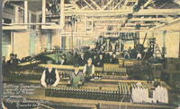
The bottling department of the Virginia Brewing Company. Virginia Brewing was located in the 1200 block of Wise Avenue SE.
PCS 58.2
Interior view of Martha Washington Candies, formerly located at 310 S. Jefferson Street.
PCS 58.1
Martha Washington Candies was located at 310 S. Jefferson Street.
PCS 58.0
Interior view of Martha Washington Candies, formerly located at 310 S. Jefferson Street.
PCS 57.0
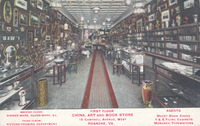
Interior view of China, Art, & Book Store, formerly located at 15 Campbell Avenue SW.
PCS 56.2
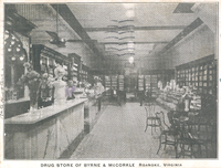
Interior view of Byrne & McCorkle Drug Store, formerly located at 207 S. Jefferson Street.
PCS 56.1
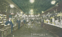
An interior view of Keyser-Warren Drug Company, formerly located at 106 Salem Avenue SW.
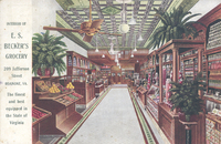
PCS 56.0
An interior view of E.S. Becker's Grocery, formerly located at 209 S. Jefferson Street.
PCS 55.2
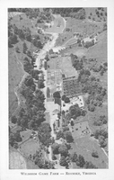
An aerial view of Wildheim Game Farm, a private zoo owned by J.J. Bower on Peters Creek Road. The zoo contained thousands of birds and small animals from all over the world.
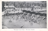
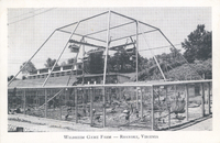
PCS 55.1
Wildheim Game Farm was a private zoo owned by J.J. Bower on Peters Creek Road. The zoo contained thousands of birds and small animals from all over the world.
PCS 55.0
Wildheim Game Farm was a private zoo owned by J.J. Bower on Peters Creek Road. The zoo contained thousands of birds and small animals from all over the world.
PCS 54.0
Roanoke Country Club was originally located in South Roanoke.
PCS 53.0
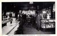
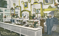
Interior view of Burrell Pharmacy, formerly located at 510 Gainsboro Road NW. Dr. Isaac Burrell is on the left.
PCS 52.0
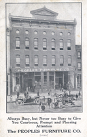
People's Furniture Company was located at 118-120 Salem Avenue SW.
PCS 51.0
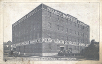
Nelson Hardware Company warehouse. The building is located at 207 Bullitt Avenue SE.
PCS 50.0
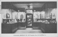
Interior view of Roanoke Jewelry Company, formerly located at 107 Campbell Avenue SW.
PCS 5.7
Greene Memorial United Methodist Church is located at 402 2nd Street SW.
PCS 5.6
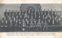
Young Business Men's Class of First Baptist Church.
PCS 5.5

The old First Baptist Church, formerly located on opposite side of 3rd Street from the current building.
PCS 5.4
The parsonage of St. James Methodist Episcopal Church was located in the 300 block of 5th Street NW.
PCS 5.3
First Methodist Episcopal Church parsonage. The church and parsonage were located on the corner of Gilmer Avenue and Commonwealth Avenue NE.
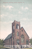
PCS 5.2
Progressive Brethren Church was located at 620 Salem Avenue SW.
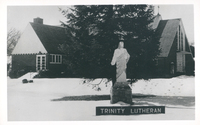
PCS 5.1
Trinity Lutheran Church is located at 4040 Williamson Road.
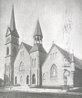
PCS 5.0
Enon Baptist Church is one of the oldest Baptist churches in the Roanoke Valley. Built in 1855 across from the entrance of present-day Hollins University, the church was established by Charles Cocke, president of Hollins Institute.
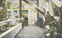
PCS 49.2
Interior view of Mitchell's Clothing, formerly located at 307 1st Street SW.
PCS 49.1
Interior view of Mitchell's Clothing, formerly located at 307 1st Street SW.
PCS 49.0
Interior view of the first floor and mezzanine of Mitchell's Clothing, formerly located at 307 1st Street SW.
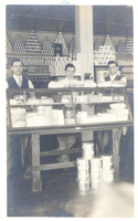
PCS 48.2
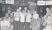
Lester Leap and Jacob Patterson in front of their grocery store, Hunter & Company at 143-145 Salem Avenue SW.
PCS 48.1
Interior view of Hunter & Company grocers was located at 143-145 Salem Avenue SW. Lester Leap and Jacob Patterson were proprietors.
PCS 48.0
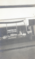
Hunter & Company grocers was located at 143-145 Salem Avenue SW. Lester Leap and Jacob Patterson were proprietors.
PCS 47.0
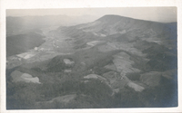
A view of the valley from McAfee Knob.
PCS 46.0
Twins Billy and Hiram Fenster were newsboys for the Union News Company. The boys sold newspapers and magazines aboard trains.
PCS 45.0
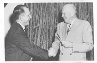
Richard Poff is given a pen by President Dwight Eisenhower. The pen was used to sign the bill enabling railroad men who have paid into the Railroad Retirement Fund and Social Security to draw from both.
PCS 44.3
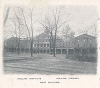
West Building on the campus of Hollins University.
PCS 44.2
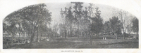
A panoramic view of the Hollins University campus.
PCS 44.1
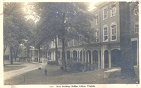
Main Building on the campus of Hollins University.
PCS 44.0

Main Building on the campus of Hollins University.
PCS 43.0
Burney Edward Witt was known as the Elliston Yodeler.
PCS 42.0
Lawrence Campbell, Walter Dale, and Gertrude Dale at 6 Campbell Avenue SE.
PCS 41.0
Hunter Coal Company was located at 1600 Cleveland Avenue SW.
PCS 40.0
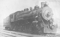
Baldwin Locomotive Engine No. 548.
PCS 4.0
Sealtest Varieties' boys, left to right: Buster Wingfield, Tommy Pendleton, Roy Hardy, and Jimmy English.
PCS 39.1
Roanoke Lodge #197 of the Benevolent and Protective Order of Elks. The lodge stood on the corner of Jefferson Street and Franklin Road where Anthem is now located.
PCS 39.0
Group photo of the Dramatic Order of Knights of Khorassan Rajah Temple No. 195 band on the steps of the Elks Club once located at the corner of Jefferson Street and Franklin Road.
PCS 38.0
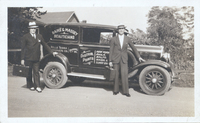
Thomas Raike and William Massey stand next to their truck, Raike and Massey sold beauty supplies for Belle-Terra Products.
PCS 37.0
The Frederick J. Kimball Memorial Fountain, carved out of red granite, was erected in 1907 by Kimball’s friends in a Shenandoah Avenue Park near the N&W passenger station. It provided water for "man and bird and beast". Horses drank from the front…
PCS 36.0
Looking north from the 900 block on Franklin Road SW
PCS 35.0
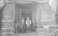
Hock's Meats was located at 15 Salem Avenue SW.
PCS 34.0
Roanoke Notion Company was located at 210 Salem Avenue SW.
PCS 33.0
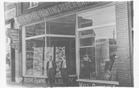
C.A. Berry Painting, Paper Hanging, and Decorating was located at 28 Church Avenue SW.
PCS 32.0
Silverman & Heyman Clothiers was located at 11 Salem Avenue SE.
PCS 31.0
An interior view of Jefferson Pharmacy, located at 315 S. Jefferson Street.
PCS 30.0
Davis & Stephenson was an insurance agency located at 112 Kirk Avenue SW.
PCS 3.9
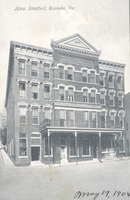
The Hotel Stratford was located at 102-106 N. Jefferson Street.
PCS 3.8
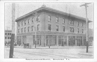
The Shenandoah Hotel opened on 5 November 1909. Originally consisting of two buildings, separated by an 8-foot alley, the Salem Avenue facing building seen here would later become the Hotel Lee followed by the Hotel Earle. The building was destroyed…
PCS 3.7
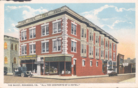
The Savoy was located at 518 2nd Street SW, currently 450 2nd Street SW.
PCS 3.6
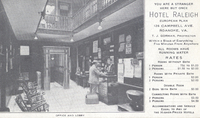
Interior of Hotel Raleigh office and lobby. Hotel Raleigh was located at 126 Campbell Avenue SW.
PCS 3.5
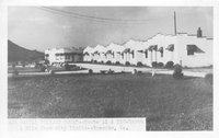
Air Castle Tourist Court was located at 7121 Williamson Road.
PCS 3.4
Air Castle Tourist Court was located at 7121 Williamson Road.
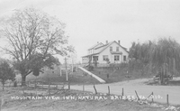
PCS 3.3
The Mountain View Inn was located in Natural Bridge.
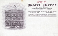
PCS 3.21
The Hotel Pierce was located on the site that would be become the Hotel Dumas.
PCS 3.20
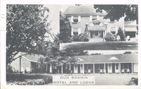
The Dun Roamin' Motel and Lodge was located at 1803 Williamson Road NE.
PCS 3.2
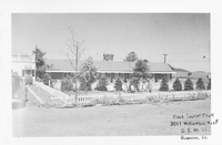
Plaza Tourist Court was located at 3011 Williamson Road. NE
PCS 3.19
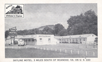
The Skyline Motel is located at 5458 Franklin Road.